Tucson, Arizona
The 50 year trail is a classic Tucson ride through some serious cattle country. In addition to the overabundant prickly pears on this trail, you're going to have to test your riding skills dodging cow patties and sometimes the cows themselves. Although it hasn't happened to me yet, the tight squeezes on this narrow trail make it a great place to snap off a derailleur hanger.
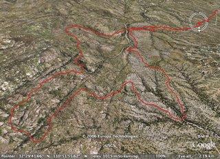
The quick loop I like to do is the more technical upper section, although I usually end up spending a good amount of time hoisting my bike up the steepest parts. You'll follow a fast windy trail from the Golder Ranch Parking lot to the infamous "chutes" area. After climbing out of the chutes, you'll enter huge boulder fields and steep canyons. The terrain is so gnarly, it amazes me that you can ride your bike through here at all. There are also probably more cacti per square inch then any other trail in this state.
The final descent from the mesa is a total blast and makes all those nasty climbs worth it: windy banked turns through boulders and prickly bushes until you finally come to this creepy dry forest with head-high grass all around you. This loop is just one of many possiblities. Enjoy.
How to get there: Head north on Oracle road about 11 miles past the intersection of Ina and Oracle. Turn right on Golder Ranch Road. You go about 2 miles before crossing a bridge and entering the dirt parking lot.
Length: 9 miles, 1-2 hours, 1000 foot climb.
Trail Conditions: The lower sections are sandy. The upper sections are heavily rutted. Still a blast to ride.
The Map: Click on the map below to head to Motionbased. There's also a good map at SDMB.
The Ride: From the Golder Ranch parking lot, cross the cattle guard and start to head left on Equestrian Road. You'll see the singletrack immediately on the right side of the road. After about 1000 feet, the singletrack will join a jeep road. Follow this jeep road for another 1000 feet and you'll see the first marked singletrack. Follow the 50 yr. trail signs north. There are lots of trails out here so its best too stay on the marked ones your first time around.
Eventually, you'll descend into the "chutes." I make a quick loop, cross two washes, and climb out of there --still following the signs for the 50 yr trail. This steep technical ascent will eventually lead you to a barbed wire fence that you'll need to cross. This section has a lot of hike-a-bike, but has some great views. After about 1-2 miles of toil, you'll cross a sandy wash and make one last ascent before descending on the killer singletrack I mentioned above. The singletrack will come out at another sandy wash. You cross that and follow trail until you come to a jeep track and a cattle guard. Cross the cattle guard, and you'll see the spot where you crossed this road earlier on the trail. Turn left and follow the trail back to your car.
Other Options: I've barely explored this place and there are a lot of great options out here. One common route is to park outside Catalina State Park and take the Lower 50 year trail all the way to the chutes. That's about a 12 mile round trip. There's some other singletrack out around Golder that I'd like to add in later postings.
 The climb up takes zen-like concentration, planning, and endurance, but if you have to dab do yourself a favor and look around.

1 comment:
30+ miles of trails here. Upper loop and Middle Gate are great, tough. There are slickrock domes, cow paths and some trails are very rocky. Closer to the mountains you go the tougher the terrain. The Chutes are a mountain bike roller coaster.
Post a Comment